
Brodick Castle Cycle Route
Brodick Castle Cycle Route
Distance: 10km
Description: Mountain Bike Ride along hilly forest roads, rough trails and tracks around the iconic Brodick Castles Gardens.
Difficulty: Medium (Suitable for all Mountain Bikers with a good level of fitness)
Park & Start
If you are arriving by car and unloading your mountain bikes it is recommended that you pull up in the car park located opposite the Arran Heritage Museum where your car can be left for the duration of the ride. From here it is but a short cycle to the Rosa Bridge and start of the Brodick Castle Cycle Route.
Route Map
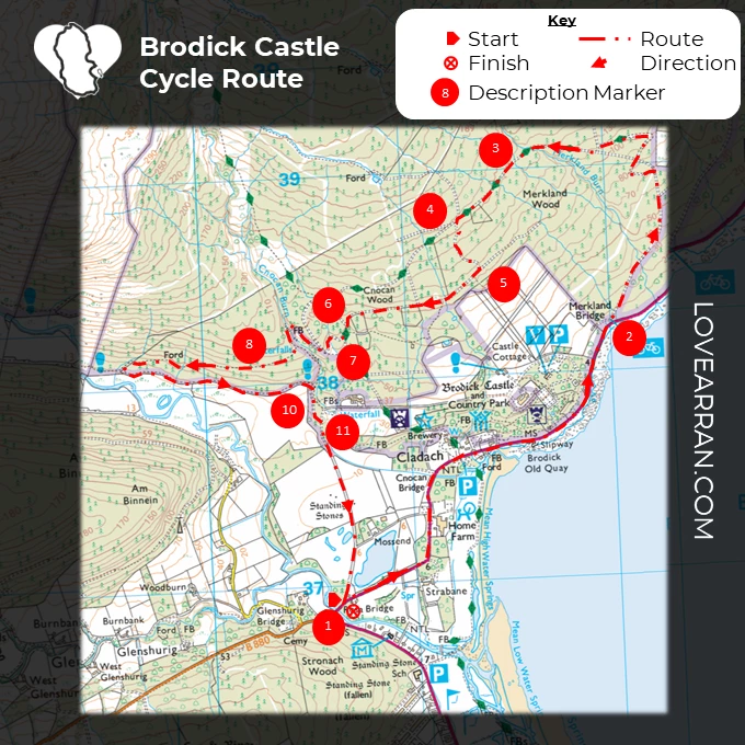
Route Description
1. The cycle begins and ends at the South Castle Gate, which is located on the A841. Continue the ride north along the coast road, passing Arran Aromatics, the Arran Brewery, and the entrance to Brodick Castle, and keep an eye out for seals sunning themselves on the rocks along this stretch. Keep going straight until you reach Merkland Wood, which is the next track on the left.
2. Climb this hard woodland road, cross a bridge, and go through a forest gate, follow the clear track as it meanders left right and left again then continue straight ahead at the next track junction to reach a bridge over Merkland Burn.
3. Stay on this woodland road as it winds its way upward until you reach a crossroads intersection at the top of the hill.
4. Take the rocky trail to the left and continue descending rather steeply until you reach the next junction.
5. Take the right fork and keep going down the track, which may be bumpy in spots. Use caution as you make your way down the steep curves until you reach the Goat Fell trail at the next T-junction. Watch out for pedestrians as well as vehicles that use the Goatfell Trail as it forms part of the Goatfell Summit Walk and is well used.
6. Take the first turn to the left and continue descending for a little distance before making a right turn at a tiny junction onto a more overgrown and grassy track. This track then turns left and continues descending to another small path intersection.
7. Make a right turn and then an immediate left turn onto a muddy route that contours around a steep-sided gully. After crossing a big wooden bridge over the river, be careful of the cliffs on the left side of the bridge. Continue to the top of the trail where it splits.
8. Take the first right down onto a rough grassy track that leads into Glen Rosa. The route will eventually come to an end at a wall that separates the forest; do not walk through the wall. Follow the muddy road that leads down to the left of the wall, being sure to watch out for hidden rocks and other obstacles along the way, and you will eventually come across the more stable path.
9. Take a left onto this route that sometimes has muddy sections; it steadily rises along the Glen Rosa field border and eventually connects with a forest road at the top of the hill.
10. Take the first right and along a wooded road until you reach Castle drive.
11. Make a right turn onto Castle Drive and continue down this road until it ends at the A841 road. As you travel along this road, keep an eye out for the standing stones that are located in the fields beyond the beech hedges.


.
